

Remnants of a 140mph hurricane hurtling towards Europe are likely to cause downpours across the UK in the coming days, forecasters warn.
Hurricane Gabrielle is now a Category 4 hurricane in the Atlantic Ocean as meteorologists believe it has the strength to cause "catastrophic damage". It is tracked to move at speed towards Europe, notably Portugal's Azores, where residents have been warned to take measures to limit any destruction.
The hurricane is not expected to cause primary damage across the UK but the remnants of it will lead to a wet and windy weekend, it is thought. Nick Finnis, meteorologist at Netweather, wrote on its blog: "It (Hurricane Gabrielle) passes east of Bermuda, before it moves towards western Europe by the weekend, injecting some tropical energy into the jet stream and heralding a return of more unsettled conditions."
While some uncertainty remains about when exactly the deluge will arrive, it is expected it'll be particularly wet - and thundery - across the Midlands and then the East of England on the weekend. More than 12mm of rain is anticipated to lash across Lincolnshire and Nottinghamshire in just a few hours.
READ MORE: US warned Hurricane Gabrielle is 'danger to life' as UK braced for strong winds
READ MORE: Lawns will be greener and ready for cold weather in 7 days if you do 1 task now
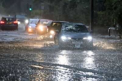
The latest downpours follow heavy rain on Saturday, which led to flooding across parts of the Northwest of England. Cars were submerged in Salford, Greater Manchester, and waterways across north Wales also burst their banks.
But there are only a handful of flood warnings and alerts in place now, including concern for campsites near Keswick, Cumbria and the Upper River Ouse in York. Nevertheless, the Met Office also recognises the unsettled picture anticipated for most regions on the weekend.

Its website says: "An uncertain period but on balance we are likely to see a change from the settled conditions of the previous days to something more unsettled through the coming weekend. This will most likely see a band of rain reaching western areas of the UK on Saturday, then gradually and erratically working its way east across most of, if not all of the country through Sunday. This could bring some heavier rain in places."
Gabrielle had maximum sustained winds of 140 mph (220 kph) on Monday afternoon as it skirted to the east-southeast of Bermuda. It was centred 180 miles away from Bermuda on Monday afternoon and moving to the north-northeast at 12 mph.
The hurricane is gathered intensity in the past 24 hours in warm Atlantic waters. Swells from the storm reached Bermuda on Sunday and were impacting the US east Coast, from North Carolina northward to Canada's Atlantic coast. Forecasters said the swells were likely to cause "life-threatening surf and rip current conditions." The Atlantic's hurricane season ends on November 30.
You may also like

Cook 'juicy and perfect chicken' with chef's easy traybake recipe
Chaotic start to Donald Trump's UN speech as he warns someone's in 'big trouble'
SC allows CBI to register more cases in builder-bank nexus
Meera Singh's Success Story Showcases Power Of Women In Yogi's Mission Shakti Campaign
"Migration from Bihar a very big issue, state's problems and unemployment are part of debate": Congress' Shakeel Ahmad on CWC meet


